GNFAC Avalanche Forecast for Sat Feb 3, 2018
<p>The equation is pretty simple around Cooke City. Heavy snow and strong winds are creating very dangerous avalanche conditions. Over the past 24 hours more than a foot of snow has fallen totaling 1.1” of SWE. This heavy shot of snow was accompanied by strong winds out of the west. Today, I expect natural and human triggered avalanches to occur on wind loaded slopes. Avoid all wind loaded terrain and be extra cautious when traveling in avalanche run out zones (<a href="https://www.youtube.com/watch?v=cj2Qhn1ldQA&list=PLXu5151nmAvQSYtIf…;
<p>Non-wind loaded slopes also pose a significant avalanche threat. Storm slabs will be easy to trigger in steeper terrain. Yesterday, Alex skied up Republic Creek south of town and found steep, non-wind loaded slopes to be touchy to human triggers. I expect steep slopes to be even more reactive today. Slides have the potential to step down to buried surface hoar 2-3’ deep or weaker layers near the ground (<a href="https://www.mtavalanche.com/images/18/natural-avalanche-woody-ridge"><s…;, <a href="https://www.mtavalanche.com/images/18/propagation-surface-hoar-near-coo…;). Today's a great day to seek out lower angle terrain while practicing cautious route-finding and conservative decision making.</p>
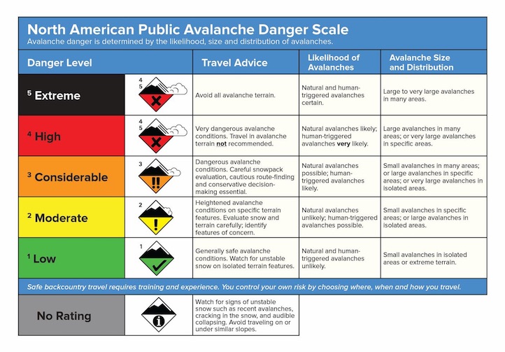
<p>Today, very dangerous avalanche conditions exist on wind loaded slopes which have a <strong>HIGH</strong> avalanche danger. Non-wind loaded slopes have a <strong>CONSIDERABLE</strong> avalanche danger.</p>
<p>Today, wind loaded slopes are the main concern in the mountains around West Yellowstone. Four to six inches of new snow over the past few days combined with moderate to strong winds out of the west will create a fresh batch of wind slabs (<a href="https://www.mtavalanche.com/images/18/small-avalanche-lionhead"><strong…;). Watch for wind loaded slopes below ridgelines and on the leeward side of cross-loaded terrain features.</p>
<p>Buried surface hoar continues to produce unstable test results and is the main layer of concern. This pesky weak layer does not exist on all slopes so digging a pit and doing a quick stability test is an easy way to stack the deck in your favor. (<a href="https://youtu.be/thn9hnFUi4Y"><strong>video</strong></a><strong>, </strong><a href="https://www.mtavalanche.com/photos"><strong>photo</strong></a>). Facets near the ground are getting stronger, but still hold the potential to produce large slides in isolated areas.</p>
<p>Today, human triggered avalanches are possible and the avalanche danger is rated <strong>MODERATE</strong>.</p>
<p>Yesterday's fast moving storm dropped 6” inches of snow in the Bridgers and 3-5” around Hyalite and Big Sky. The new snow was easily transported by strong westerly winds. Yesterday, both Big Sky and Bridger Bowl Ski Patrols found wind loaded slopes to be reactive during control work. Slides are staying confined to the new snow, but have enough volume to carry and potentially bury a skier or rider. Warm temps will make wind slabs a little stubborn, but they still can’t be trusted, especially in steep high consequence terrain (think Saddle Peak). The snowpack is mostly stable on non-wind loaded slopes (<a href="https://www.youtube.com/watch?v=-Kh4wvvQ3Wk"><strong>video</strong></a>…;
<p>Today, the avalanche danger is rated <strong>MODERATE</strong> on all wind-loaded slopes and <strong>LOW</strong> elsewhere. The avalanche danger could rise if this evening’s storm arrives earlier than forecasted.</p>
<p>If you get out and have any avalanche or snowpack observations to share, drop a line via our <a href="https://www.mtavalanche.com/node/add/snow_observation">website</a>, email (<a href="mailto:mtavalanche@gmail.com">mtavalanche@gmail.com</a>), phone (406-587-6984), or Instagram (#gnfacobs).</p>
Today! King and Queen of the Ridge
King and Queen of the Ridge. A Hike and Ski/Ride-a-Thon fundraising event to support the Friends of the Gallatin National Forest Avalanche Center. Join the party today at Bridger Bowl.
Upcoming Avalanche Education and Events
BOZEMAN